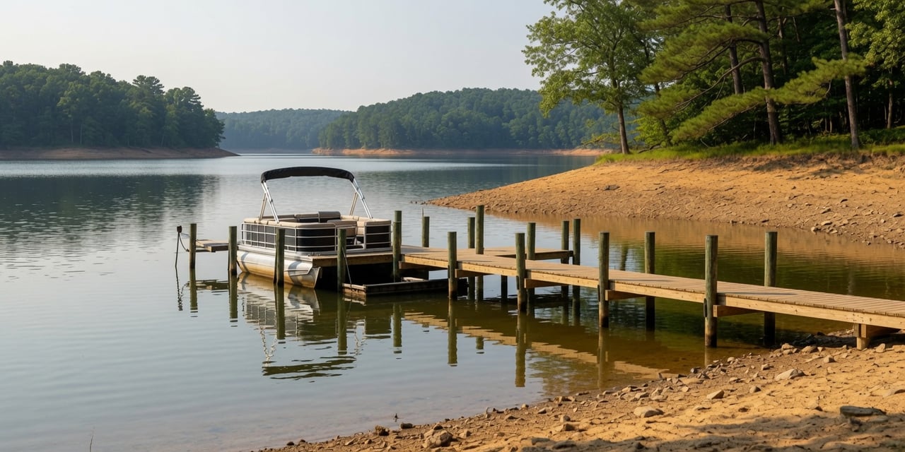
Smith Mountain is down more than 5 feet. Kerr is down 5.4. Lake Anna? Under 2. The comparison nobody at the lake is making might change how you feel about our water.
If you've spent any time on a Lake Anna group chat this summer, you know the number one topic: the water level. We're about 1.9 feet below full pond, docks are sitting higher than anyone likes, and everyone wants to know when it comes back.
Here's the question almost nobody is asking: compared to what?
Virginia is working through its second-driest water year on record. Every major lake in the Commonwealth is feeling it. So we pulled the current numbers for the state's big recreation lakes, and the comparison might change how you feel about our lake.
The Scoreboard
Here's where Virginia's major lakes stood as of late July, measured in feet below full pond:
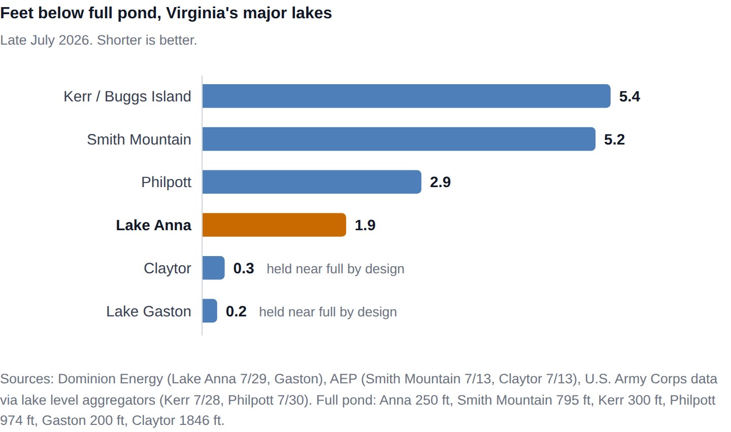
One honest footnote on Gaston and Claytor: they're held near full pond by design. They're pass-through reservoirs whose operators pin the level tightly year-round, so they're not really in the same conversation. Among Virginia's big lakes that actually absorb a drought, the standings are: Kerr down 5.4, Smith Mountain down 5-plus, Philpott down about 3, and Lake Anna down 1.9.
Lake Anna is the least drawn-down major recreation lake in drought-affected Virginia.
What Low Water Looks Like Elsewhere
At Smith Mountain Lake this month, the story is exposed sandbars, rocks in places boaters have never seen them, and officials urging extra caution after a string of groundings. Homeowners are wrestling with docks and boat lifts that no longer reach the water. The Roanoke region was declared a drought emergency in mid-July, and the Governor visited the lake to urge conservation. To their credit, SML's tourism leaders are making the same case we make here: the lake is still open for business, and there's plenty of water to enjoy.
Sound familiar? It's the same season we're having at Lake Anna, except their version is more than five feet deep and ours is under two.
The Numbers Are Actually Improving
This week's U.S. Drought Monitor update brought the best news in months. The share of Virginia in severe drought or worse fell by more than 16 points in a single week, down to about 30%, and extreme drought shrank to about 8% of the state. Around 72% of Virginia remains in some level of drought, so nobody is declaring victory, but the trend finally turned the right way.
The forecast is cooperating too. Weather models show a wetter, more active pattern for central Virginia over the next two weeks, with the best chance of meaningful rain early next week.
One number worth knowing: if the lake slips below 248 ft, Dominion's state permit allows it to begin reducing the release from the North Anna dam in stages, from 40 cubic feet per second down to a minimum of 20. That's a built-in brake that slows the outflow and helps protect the lake level. We're currently a tenth of a foot above that trigger, so the lake has a safety valve it hasn't even needed to use yet.
"That Does Not Look Like 2 Feet to Me"
We hear this one every week, usually while standing on someone's dock: Dominion says the lake is down about 2 feet, but the pylons and the boat slips say otherwise. It looks way lower than that.
You're not imagining it, and Dominion isn't fudging the number. Both things are true at once, and the explanation is geometry, not measurement error.
The gauge measures vertical. Your eyes see horizontal. The lake level is a vertical measurement taken at the main dam. But what you see from shore is horizontal: how far the waterline has walked away from your riprap. On a steep shoreline, a 2-foot drop barely moves the waterline. On a gently sloped lot, every vertical foot can pull the water 10, 15, even 25 feet out across the exposed lake bed.
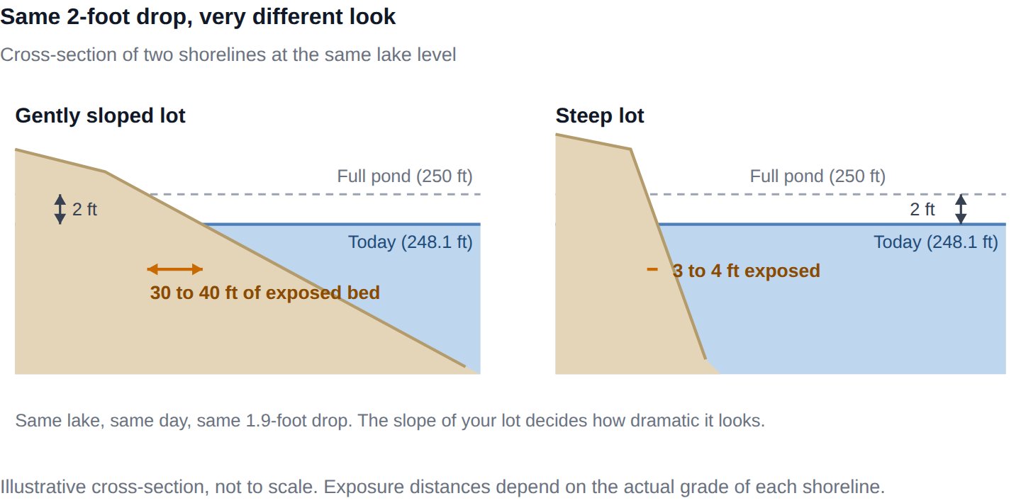
Location on the lake changes everything. The level is essentially uniform lake-wide, but depth is not. The upper reaches and the backs of coves are naturally shallow and hold years of accumulated silt washed down from the feeder creeks. A cove that carries 3 feet of water at full pond may be down to inches right now, unusable for anything with a prop, while the main channel a quarter mile away is barely changed. The people saying "it looks way lower than 2 feet" usually live up a creek arm. The people shrugging usually live on the main basin. Both are right.
Everything you judge by was built for full pond. Docks, boat lifts, slips, swim ladders, and beaches were all installed against a 250-foot lake. Drop the water 2 feet and boats sit visibly low in their slips, lift bunks hang in the air, and the bottom rungs of ladders dangle above the surface. It reads as dramatic even where the water behind the dock is fine.
The stain line lies. The dark water mark on pylons and riprap records the highest water the lake has held, not its typical summer level. The lake normally rides a little below full pond in late summer anyway, so eyeballing the gap between the stain line and today's surface will always overstate the true deficit.
None of this makes the low water fun, especially if your cove is one of the shallow ones. But it does mean the official number and your eyes can both be trusted, as long as you know which question each one is answering.
What This Means If You Own (or Want to Own) Here
Perspective matters in two directions.
If you own at Lake Anna: your lake is weathering a historic drought better than any comparable lake in the state. The structural reasons are real: a 13,000-acre lake with a nuclear station whose operations depend on managing that water carefully, a defined full pond, and a release permit designed to protect the level. The lake has also recovered from every drought in its 50-year history, which we covered in our low water level breakdown.
If you're shopping: some buyers are sitting out every Virginia lake this summer because of drought headlines. The headlines are mostly about lakes that are down five feet. At the lake that's down less than two, that hesitation is creating opportunity, which we broke down in this week's market post. When you're comparing lake markets, compare the water too.
Talk to the team that tracks the water
We'll keep tracking the levels here every week, ours and the competition's. If you want to talk about what the water means for your property or your plans, reach out at [email protected] or 540-870-0437. And if you're weighing Lake Anna against another lake, start with our buyer's guide, or let us know if you're thinking about selling.
Sources: Dominion Energy North Anna/Lake Anna levels page; AEP hydro recreation water levels (Smith Mountain, Claytor); U.S. Army Corps data via lake level aggregators (Kerr, Philpott); Dominion Lake Gaston levels page; U.S. Drought Monitor Virginia, 7/30/2026 release; WSET and WSLS coverage of Smith Mountain Lake, July 2026; Governor of Virginia July 2026 drought releases; Lake Anna Life on the North Anna dam release permit.
